International Journal of Civil Infrastructure (IJCI)
ISSN: 2563-8084

Volume 8 - Year 2025- Pages 124-132
DOI: 10.11159/ijci.2025.013
Assessment of Surface Displacement at Ash Dam Facility Utilising InSAR
Rebecca Alowo1, Daphine Achiro2, Innocent Musonda3, Agneta Were4, Adetayo Onososen5, Funeka Grootboom6
1,2,3,4,5Centre of Applied Research and Innovation in the Built Environment (CARINBE), Faculty of Engineering and the Built Environment, University of Johannesburg, 55 Beit Street Johannesburg, South Africa
ralowo@uj.ac.za, achydaphinar@gmail.com, imusonda@uj.ac.za, ayoo.achieng@gmail.com, adetayoo@uj.ac.za
6Eskom Holdings SOC Ltd
GrootbFA@eskom.co.za
Abstract - This research delineates the assessment of surface displacement at the Ash Dam Facility in South Africa utilizing InSAR technology. ADF may fail owing to several circumstances, including structural instability, seepage, or seismic activity. Consequently, the application of InSAR technology necessitates the rapid identification and response to hazards in order to limit repercussions such as loss of life and property resulting from dam failures. Interferometric Synthetic Aperture Radar (InSAR) is an advanced remote sensing technology that is essential for assessing the safety and integrity of ash dams. The study utilized Vertex, the Alaska Satellite Facility's (ASF) data search application for remotely sensed imagery, facilitating efficient identification and download of SAR data, along with direct access to thematic datasets. ASF Data Search is a user-friendly tool for locating SAR data and efficiently processing advanced SAR products, including InSAR and Auto-RIFT, through ASF's services. The research performed a time series analysis with Mintpy on the OpenSAR Lab server. The Mintpy toolbox is a Python 3 application designed for modest baseline InSAR time series analysis. The input consists of a series of differential interferograms that create a completely interconnected network. The results indicated that the ash dam facility has experienced a total vertical displacement of 200 cm and a lateral displacement of 310 cm. The coordinates of the impacted area are (7145360, 739280) and (7160480, 714480) in terms of latitude and longitude. In conclusion, satellite remote sensing provides a cost-effective and time-efficient means to monitor extensive infrastructure assets, a task that would otherwise need significant resources through traditional approaches.
Keywords: Ash Dam Facility, Surface Displacement, InSAR, South Africa
© Copyright 2025 Authors - This is an Open Access article published under the Creative Commons Attribution License terms. Unrestricted use, distribution, and reproduction in any medium are permitted, provided the original work is properly cited.
Date Received: 2025-08-13
Date Revised: 2025-08-20
Date Accepted: 2025-09-02
Date Published: 2025-10-01
1. Introduction
The project aims to oversee ash dam facilities (ADF) and provide an early warning system for a power producing plant. The geomatics systems track many data kinds, encompassing water quality, structural integrity, and seepage [1]. The particular advantages of the real-time data monitoring study focus on enhancing safety, ensuring environmental compliance, and providing early warnings of any structural issues [2]. The project tackles the environmental issues associated with coal-generation infrastructure and will enhance the safety of the ADFs.
Interferometric synthetic aperture radar (InSAR) is a radar methodology employed in geodesy and remote sensing that utilizes two or more synthetic aperture radar (SAR) images to produce maps of surface deformation or digital elevation by analyzing variations in the phase of the waves returning to the satellite or aircraft. The approach has the capacity to monitor millimeter-scale variations in deformation across a time series [4]. It is utilized in geophysical monitoring of natural hazards such as earthquakes, volcanoes, and landslides, as well as in structural and geotechnical engineering for monitoring subsidence and structural integrity. Civil engineering, mining, and infrastructure require great spatiotemporal accuracy, precision, and detail in observations and measurements. Satellite-based remote sensing methods can generate data and information of a quality that meets these standards [6].
Geotechnical engineering technology and best practices have advanced considerably during the past two decades. Remote survey strategies for data capture facilitate the acquisition of discontinuity orientations and roughness in hard-to-reach regions [8]. Software development has advanced to a point where several model scenarios may be executed swiftly, and intricate numerical 3D analyses are frequently performed for bigger projects [9]. In contrast to optical imaging, radar waves can penetrate clouds and function effectively at night [10]. InSAR analyzes several satellite radar pictures over time to accurately quantify surface displacement changes and is efficiently utilized for monitoring both natural terrain and artificial surfaces [11].
2.0 Literature Review
Interferometric synthetic aperture radar (InSAR) is a radar methodology employed in geodesy and remote sensing that utilizes two or more synthetic aperture radar (SAR) images to produce maps of surface deformation or digital elevation, based on variations in the phase of the waves returning to the satellite or aircraft. The approach has the capacity to quantify millimeter-scale variations in deformation throughout a temporal sequence [4]. It is utilized in geophysical monitoring of natural hazards such as earthquakes, volcanoes, and landslides, as well as in structural and geotechnical engineering for monitoring subsidence and structural integrity [9]. Civil engineering, mining, and infrastructure require great spatiotemporal accuracy, precision, and detail in observations and measurements [7]. Satellite-based remote sensing methods can generate data and information that meet these standards [10].
Geotechnical engineering technology and best practices have advanced considerably over the past two decades [12]. Remote survey strategies for data capture facilitate the acquisition of discontinuity orientations and roughness in hard-to-reach regions [8]. Software development has advanced to a point where several model scenarios may be executed swiftly, and intricate numerical 3D analyses are frequently conducted for bigger projects [9]. In contrast to optical imaging, radar waves can penetrate clouds and function effectively at night [10]. InSAR analyzes several satellite radar pictures over time to accurately quantify surface displacement changes and can be efficiently utilized to monitor both natural terrain and artificial surfaces [11].
3.0 Methodology
The researchers performed a historical displacement analysis using a three-year retrospective InSAR assessment along the ADF, facilitating the identification of regions undergoing displacements and the formation of ground behaviour trends. Analysing movement patterns uncovers intervals of stability and regions influenced by ground movement acceleration [13]. InSAR technology is preferred for its capacity to deliver monitoring data continuously, regardless of time or weather, and especially for extensive areas with millimetre-scale precision, in contrast to traditional approaches that are labour-intensive, expensive, and occasionally impractical [14]. Acquiring settlement data using traditional in-situ approaches would have necessitated a delay of several months to gather adequate information [15]. InSAR provides access to many years of historical settlement data, facilitating the prediction of future patterns [14]. Longitudinal conventional survey data can offer a significant chance to validate the satellite methodology [16].
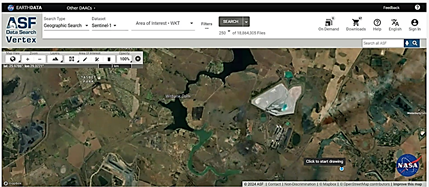
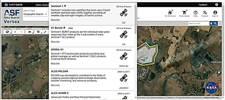
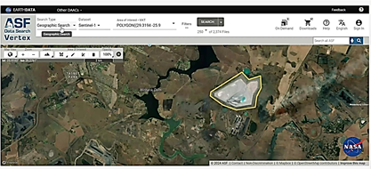
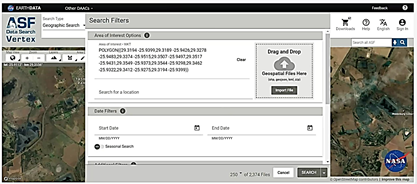
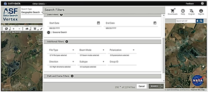
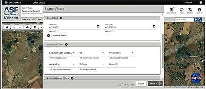
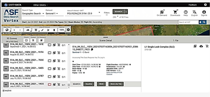
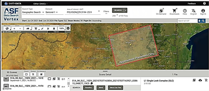
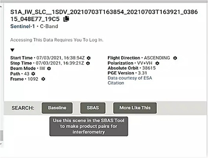
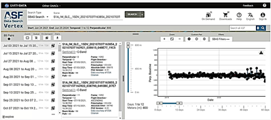
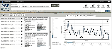
Vertex is the Alaska Satellite Facility's (ASF) data search program for remotely sensed Earth images, facilitating efficient discovery and download of SAR data, along with direct access to themed datasets [17]. ASF Data Search is a user-friendly tool for locating SAR data and efficiently processing advanced SAR products, including InSAR and Auto-RIFT products, utilizing ASF's HyP3 service [16]. The ASF DAAC provides three methods for data search and download: over the web using Vertex, programmatically through the Python Search Module/Mintpy, and through ASF's established Search Application Programming Interface. ASF is accessible via Earth Data Search.
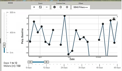
We performed a time series analysis utilizing Mintpy on the OpenSAR Lab server. The Mintpy toolbox is a Python 3 application designed for modest baseline InSAR time series analysis [19]. The input consists of a series of differential interferograms that create a completely interconnected network. Interferograms must be pre-unwrapped with minimal geometric perpendicular and temporal baselines to optimize their quality [20]. Modern SAR constellations with narrow orbital tubes and brief revisit intervals, like Sentinel-1, may readily establish a comprehensive network of interferograms [21] (Bonano et al., 2024). The input stack can be produced with, among other instruments, the Interferometric SAR Scientific Computing Environment (ISCE) [22]. The primary stages of interferometric processing executed by ISCE include orbit correction, de-bursting, co-registration, interferogram creation, adaptive filtering, topographic phase subtraction utilizing a provided Digital Elevation Model (DEM), and two-dimensional (spatial) unwrapping [23].
The Mintpy toolbox comprises three primary processing stages: (a) computation of the raw interferometric phase time series; (b) rectification of the raw phase time series to eliminate error sources; and (c) assessment of noise, leading to the exclusion of noisy SAR acquisitions and the final computation of noise-reduced displacement time series [19]. Additionally, a quality index for the retrieved deformation values is determined by calculating temporal coherence for each pixel.
The initial processing step of Mintpy involves inverting the redundant input, a fully connected stack, using an unbiased weighted least squares estimator to obtain raw time series of interferometric phase for each date [19]. The weight information may pertain to uniform behaviour or absence of weighting, spatial coherence at the pixel level, the inverse of phase variance, and the nonparametric Fisher information matrix (FIM) [24]. This study exclusively utilized the inverse of phase variance weighting, as it provides the most robust performance for network inversion, particularly with a limited number of views.
The second processing step involves correcting the raw inverted phase time-series for phase error sources in the time domain. Deterministic elements, including tropospheric delays, topographic residuals, and/or phase ramps, are retained post-inversion and can be mitigated in the time-series domain to yield a time series of noise-reduced displacements [25]. Additionally, a correction technique for mistakes in the 2D unwrapping procedure utilizing several methodologies is shown. The chosen unwrapped correction method pertains to the phase closure of triplet interferograms, predicated on the premise that the SAR phase field is conservative [26].
The third step involves assessing the noise of each SAR acquisition concerning the residual phase. Mintpy regards the residual phase as a synthesis of residual tropospheric turbulence, unmitigated ionospheric turbulence, and the residual decorrelation noise [27]. The root mean square error of the residual phase is computed for each SAR acquisition following a quadratic deramping across the reliable pixels utilized in the network inversion [28]. Noisy acquisitions are removed, and the topographic residual and velocity estimation are conducted a second time [29]. Figures 1 to 13 illustrate the procedures employed to analyse displacement for the Duvha fly ash dam plant.
4.0 Findings
To assess displacement, wrapped images are submitted to InSAR, where coherence is evaluated using baselines, and interferograms are subsequently analyzed for errors, leading to the determination of displacement. The same is true for moisture content analysis.
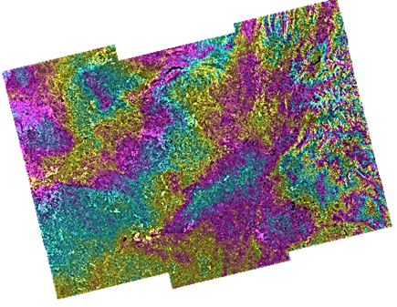
The InSAR monitoring depends on images, which must be wrapped. What is the reason? This enables the successful modeling of extensive areas of interest with a high degree of precision. Figure 14 presents a wraparound depiction of the ash dam facility.
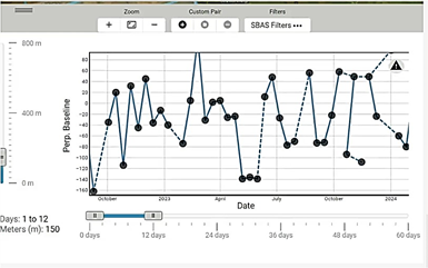
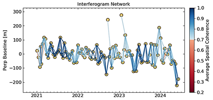
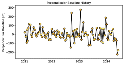
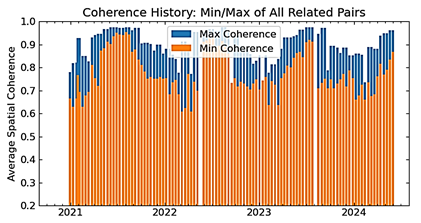
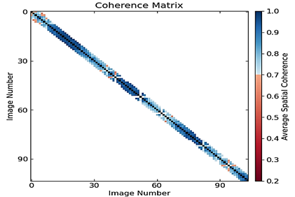
Executing plot_network.py provides a comprehensive picture of the network (fig. 15 and fig. 16) and the average coherence of the stack in fig. 19. The application generated several files as detailed below:
- text: includes interferogram dates, average coherence, and spatial baseline separation (see to Fig. 15). Deformation estimation is conducted via the unwrapping of the interferometric phase.
- pdf: illustrates the network of interferograms in time baseline coordinates, color-coded according to the average coherence of the interferograms (see to fig. 16). Deformation estimation is conducted via the unwrapping of the interferometric phase.
- pdf illustrates the average coherence pairs among all accessible pairs in the stack, specifically figures 17 and 18.
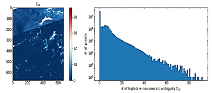
The researchers needed to analyse the quantity of interferogram triplets exhibiting non-zero phase closure. In an interferogram triplet (DQij, DQjk, and DQik), unwrapping problems will result in a non-zero integer component Cijk int within the closing phase Cijk. Consequently, the quantity of interferogram triplets exhibiting non-zero integer ambiguity Tint can be utilized to identify unwrapping issues.
Cijk = DQij + DQjk - DQik (1)
Cijk int = [Cijk – wrap (Cijk)] /2 π (2)
T int =∑ Cijk int! =0 (3)
Where warp is an operator that constrains the input number to the interval [-π, π]; T is the quantity of interferogram triplets. As previously stated, errors must be eliminated through the investigation and eradication of unaddressed discrepancies. Figure 19 presents a histogram depicting the frequency of triplets exhibiting non-zero integer ambiguity. The key insights derived from the Tint map and histogram are as follows:
- Areas with T int> 0 have unwrapping errors
- The areas sharing the common positive T int Value could be corrected
- The areas with wide – distributed T int values indicates random unwrapping errors which are difficult to correct so we did not correct these.
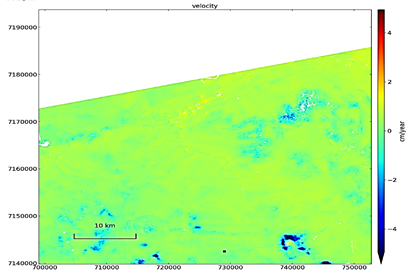
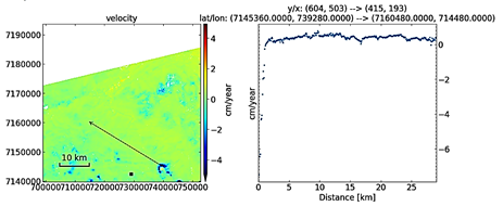
To determine displacement, a velocity graph must be constructed. The min/max values in this figure require adjustment to align with our previous data set. The results depicted in figures 20 and 21 illustrate the data range previously addressed about coherence and baseline adaptation. This graphing can be performed initially to gather information and subsequently re-executed to implement adjustments. We revised the Vmin and Vmax to align with our data range. The assigned Vmin and Vmax values may also be utilized for supplementary graphs. In the colour scale of these displacement/velocity charts, green signifies zero deformation, whilst blue indicates deformation below zero. In Figure 20 below, the blue areas indicate the area of concern with documented displacement. Figure 21 illustrates a total vertical displacement of 200 cm and a lateral displacement of 310 cm. The coordinates of the impacted region are (7145360, 739280) and (7160480, 714480) correspondingly.
The negative numbers indicated regions of ground depression, whilst the positive ones denoted areas of ground elevation. In the colour scale of these displacement/velocity charts, green signifies zero deformation, whilst blue indicates deformation below zero. In Figure 20 below, the blue spots indicate the regions exhibiting the most deformation. The negative deformation indicates a significant moisture content in these locations. These locations may signify the critical junctures where the observed deformation could provide issues. Figure 21 illustrates a total vertical displacement of 200 cm and a lateral displacement of 310 cm.
5.0 Implication InSAR
- Historical InSAR analysis will yield significant insights into ground behavior trends.
- Continuous InSAR monitoring will provide proactive oversight of a power plant and its vicinity, enabling the early detection of deformations that warrant further investigation before they escalate into significant and costly issues.
- InSAR enhances in-situ monitoring and assists in identifying and prioritizing high-risk locations. This leads to enhanced resource utilization and a decrease in carbon footprint.
- Operations do not need to be suspended for monitoring, as this is a remote procedure.
- Geotechnical analysis of the results to evaluate the extent of influence of the detected patterns.
- Operators and dam safety officers can concurrently access results via a secure web-based platform, eliminating the necessity to handle multiple data sources or visit instrument locations.
- Automatic warnings can be established when ground movement beyond a predetermined threshold, facilitating early identification and rectification of issues, which is invariably a more cost-effective strategy.
- Ultimately, satellite remote sensing provides a cost-effective and time-efficient means to monitor extensive infrastructure assets, which would otherwise need significant resources through traditional approaches.
Additional advantages of employing InSAR technology include:
- elevated spatial resolution of monitoring locations,
- more precision than LiDAR or UAV surveys,
- Regular weekly updates are feasible.
- The most secure approach for asset monitoring.
- No concerns with site accessibility.
- No permanent monitoring equipment necessary.
- historical modeling is feasible, and
- weather agnostic
6.0 Conclusions and recommendations
The researchers aimed to establish a proof of concept for ash dam monitoring (geomatics) via Interferometric Synthetic Aperture Radar (InSAR). Consequently, the recommendations ought to be confined to the proof of concept for INSAR in the monitoring of ash dams. We aimed to accurately model extensive areas of interest to ascertain surface displacement for the historical and current monitoring of the ash storage facility, identify problematic locations for further localized investigation, and facilitate effective risk management of the site and assets reliant on the computed displacement trends. The region in figures 21 and 22, indicated in blue on the velocity/displacement map, which has seen a total displacement of 200 cm vertically and 310 cm horizontally, presents a risk. Nevertheless, there are no adjacent infrastructures, and the movement may not influence substantial slopes. The coordinates of the impacted region, (7145360, 739280) and (7160480, 714480), require reinforcement. This requires vigilant oversight. To summarize:
- It is essential to comprehend the catalysts of the movements, together with the accelerations resulting from alterations in the border conditions.
- Furthermore, it is essential to examine whether the triggering parameters have evolved over time to coincide with the trend alterations in displacements.
InSAR is an effective remote sensing technology that has demonstrated its worth in monitoring the stability and integrity of ash dams. InSAR provides consistent, periodic monitoring, facilitating the prompt identification of alterations that may jeopardize the structural integrity of the ash dam. InSAR operates by quantifying the phase variation between two radar images of an identical region, enabling the detection of surface displacements as minute as millimeters. The elevated sensitivity of InSAR renders it an exceptionally valuable instrument for observing potential ground deformation or subsidence near ash dams, which may signify structural instability.
A significant benefit of this technique is that a single radar image can encompass a substantial region of up to 100 km by 100 km or greater, similar to how satellite data spans a width of 250 km. InSAR technologies yield extensive data that may be readily compared with traditional geodetic observations. InSAR offers the benefits of extensive spatial coverage at minimal expense, consistent temporal data collecting, and access to substantial historical data archives for retrospective analyses. Nevertheless, this technology has not yet been embraced by the South African industry.
7.0 Acknowledgement/Funding
This study is part of a collaborative effort at ESKOM, the Centre for Applied Research and Innovation in the Built Environment (CARINBE). It was financed under task order 2, pertaining to the research and development of a proof of concept for ash dam monitoring (Geomatics), under the project titled: Civil & Structural Engineering and Ash Dams, contract number: 4600074129. The authors assert that there is no conflict of interest.
7. References
[1] V.M. Rădulescu, G.M. Rădulescu, S.M. Naș, A.T. Rădulescu, and C.M. Rădulescu, 2024. Structural Health Monitoring of Bridges under the Influence of Natural Environmental Factors and Geomatic Technologies: A Literature Review and Bibliometric Analysis. Buildings, 14(9), p.2811. View Article
[2] C. Cacciuttolo, V. Guzmán, P. Catriñir, and E. Atencio, 2024. Sensor Technologies for Safety Monitoring in Mine Tailings Storage Facilities: Solutions in the Industry 4.0 Era. Minerals, 14(5), p.446. View Article
[3] P.J. González, 2024. Interferometric Synthetic Aperture Radar (InSAR). In Remote Sensing for Characterization of Geohazards and Natural Resources (pp. 53–73). Cham: Springer International Publishing. View Article
[4] K. He, L. Lombardo, L. Chang, N. Sadhasivam, X. Hu, Z. Fang, A. Dahal, I. Fadel, G. Luo, and H. Tanyas, 2024. Investigating earthquake legacy effect on hillslope deformation using InSAR‐derived time series. Earth Surface Processes and Landforms, 49(3), pp.980–990. View Article
[5] Z. Wang, J. Zhu, and T. Ma, 2024. Review on monitoring of pavement subgrade settlement: Influencing factor, measurement and advancement. Measurement, p.115225. View Article
[6] T. Dube and O. Mupepi, 2024. Climate management and policy development: An earth observation perspective. In Remote Sensing of Climate (pp. 349–375). Elsevier. View Article
[7] S.L. Kramer and J.P. Stewart, 2024. Geotechnical Earthquake Engineering. CRC Press. View Book
[8] W.K. Leung, J.C. Wong, J.S. Kwan, and D.N. Petley, 2024. The use of digital technology for rock mass discontinuity mapping: review of benchmarking exercise. Bull. Eng. Geol. Environ., 83(6), p.249. View Article
[9] L. Zhang, Y. Li, Y. Pan, and L. Ding, 2024. Advanced informatic technologies for intelligent construction: A review. Eng. Appl. Artif. Intell., 137, p.109104. View Article
[10] L. Meng, C. Yan, S. Lv, H. Sun, S. Xue, Q. Li, L. Zhou, D. Edwing, K. Edwing, X. Geng, and Y. Wang, 2024. Synthetic aperture radar for geosciences. Reviews of Geophysics, 62(3), p.e2023RG000821. View Article
[11] F. Cigna, T. Balz, D. Tapete, G. Caspari, B. Fu, M. Abballe, and H. Jiang, 2024. Exploiting satellite SAR for archaeological prospection and heritage site protection. Geo-spatial Information Science, 27(3), pp.526–551. View Article
[12] W. Gao, 2024. The Application of Machine Learning in Geotechnical Engineering. Applied Sciences, 14(11), p.4712. View Article
[13] Y. Zhu, H. Qiu, Z. Liu, B. Ye, B. Tang, Y. Li, and U. Kamp, 2024. Rainfall and water level fluctuations dominated the landslide deformation at Baihetan Reservoir, China. Journal of Hydrology, 642, p.131871. View Article
[14] A. Babaei, H. Sadeghi, and Z. Ghorbani, 2024. Deep Neural Networks for Predicting the Settlement of Earth Dams Based on the InSAR Outputs. Indonesian Geotechnical Journal, 3(2), pp.57–66. View Article
[15] Y. Tan, Y. Lu, and D. Wang, 2024. Synchronous-cross zoned excavation of the oversized basement of Shanghai International Financial Centre by combination of bottom-up and top-down methods: Structural and geotechnical behaviors. Tunnelling and Underground Space Technology, 153, p.106023. View Article
[16] M.S. Al-Batah, E.R. Al-Kwaldeh, M.A. Wahed, M. Alzyoud, and N. Al-Shanableh, 2024. Enhancement over DBSCAN satellite spatial data clustering. Journal of Electrical and Computer Engineering, 2024(1), p.2330624. View Article
[17] W. Chen, 2024. Revisiting “a hybrid UNet based approach for crop classification using Sentinel-1B synthetic aperture radar images”: a comment aided by ChatGPT. Multimedia Tools and Applications, pp.1–6. View Article
[18] E. Hauglin, 2024. Assessing rock glaciers for their hydrological significance in the Semi-arid Andes, Chile (Master's thesis, The University of Bergen). View Thesis
[19] R. Lau, C. Seguí, T. Waterman, N. Chaney, and M. Veveakis, 2024. Quantitative Assessment of Interferometric Synthetic Aperture Radar (INSAR) for Landslide Monitoring and Mitigation. In Geomorphic Risk Reduction Using Geospatial Methods and Tools (pp. 155–168). Singapore: Springer Nature. View Article
[20] Y.Y. Wu and A. Madson, 2024. Error Sources of Interferometric Synthetic Aperture Radar Satellites. Remote Sensing, 16(2), p.354. View Article
[21] M. Bonano, P. Striano, M. Yasir, S. Buonanno, F. Casu, C. De Luca, A. Fusco, Y.L.B. Roa, I. Zinno, M. Virelli, and M. Manunta, 2024. New Advances of the P-SBAS Approach for an Efficient Parallel Processing of Large Volumes of Full-Resolution Multi-Temporal DInSAR Interferograms. Authorea Preprints. View Preprint
[22] A. Zaki, L. Chang, I. Manzella, M. van der Meijde, S. Girgin, H. Tanyas, and I. Fadel, 2024. Automated Python workflow for generating Sentinel-1 PSI and SBAS interferometric stacks using SNAP on Geospatial Computing Platform. Environmental Modelling & Software, 178, p.106075. View Article
[23] F. Hu, Y. Gong, S. Cheng, and F. Xu, 2024. Amplitude-aided 3D Phase Unwrapping for Temporary Coherent Scatterers Interferometry. IEEE Transactions on Geoscience and Remote Sensing. View Article
[24] L. Fayette, K. Brendel, and F. Mentré, 2024. Using Fisher Information Matrix to predict uncertainty in covariate effects and power to detect their relevance in Non-Linear Mixed Effect Models in pharmacometrics. medRxiv, pp.2024–10. View Preprint
[25] P. Liu and X. Chen, 2024. Tropospheric atmospheric heterogeneities of ALOS2 interferograms in the Greater Bay area. IEEE J. Sel. Top. Appl. Earth Observ. Remote Sens. View Article
[26] M. Lazecký, Q. Ou, L. Shen, J. McGrath, J. Payne, P. Espín, A. Hooper, and T. Wright, 2024. Strategies for improving and correcting unwrapped interferograms implemented in LiCSBAS. Procedia Computer Science, 239, pp.2408–2412. View Article
[27] Z. Yu, G. Zhang, G. Huang, C. Cheng, Z. Zhang, and C. Zhang, 2024. SSBAS-InSAR: A Spatially Constrained Small Baseline Subset InSAR Technique for Refined Time-Series Deformation Monitoring. Remote Sensing, 16(18), p.3515. View Article
[28] Y. Cai, P. Lu, B. Li, J. Li, Y. Chen, Y. Wang, Y. Nan, R. Wang, and Y. Wu, 2024. An efficient phase error calibration method for azimuth multichannel SAR based on least spectrum difference. IEEE Transactions on Geoscience and Remote Sensing. View Article
[29] H. Hu, H. Fu, J. Zhu, Z. Liu, K. Wu, D. Zeng, A. Wan, and F. Wang, 2024. Automatic Correction of Time-Varying Orbit Errors for Single-Baseline Single-Polarization InSAR Data Based on Block Adjustment Model. Remote Sensing, 16(19), p.3578. View Article