International Journal of Civil Infrastructure (IJCI)
ISSN: 2563-8084

Volume 8 - Year 2025- Pages 133-137
DOI: 10.11159/ijci.2025.014
Analysis of Historical Moisture Content for Ash Dam Facility in South Africa
Rebecca Alowo1, Daphine Achiro2, Innocent Musonda3, Agneta Were4, Adetayo Onososen5, Funeka Grootboom6
1,2,3,4,5 Centre of Applied Research and Innovation in the Built Environment (CARINBE), Faculty of Engineering and the Built Environment, University of Johannesburg, 55 Beit Street Johannesburg, South Africa
ralowo@uj.ac.za, achydaphinar@gmail.com, imusonda@uj.ac.za, ayoo.achieng@gmail.com, adetayoo@uj.ac.za
6 Eskom Holdings SOC Ltd
GrootbFA@eskom.co.za
Abstract - This article presents a three-year investigation of moisture content conducted at the Duvha Ash Dam Facility to pinpoint areas exhibiting rising moisture content values through satellite technology. An elevation in moisture content levels may signify inadequate drainage. A historical study aids in pinpointing areas that have seen elevated moisture levels, which may be corroborated with historical data pertaining to the state of the ash dam plant. The researchers employed Soil Moisture Active Passive (SMAP) to measure soil moisture. The SMAP mission is an orbital observatory that quantifies the water content in the surface soil globally. Soil moisture is a crucial metric for meteorological forecasting, assessing drainage failures, and predicting droughts and floods. The researchers employed SMAP radiometers to quantify radiation data for the calculation of water content. The results indicated that the soil moisture at the ash dam facility is 0.09 cm³/cm³. Furthermore, soil moisture peaks throughout the summer months near the ash dam site. Soil moisture is diminished throughout the cold months. Monitoring soil moisture throughout the hot months is essential. In conclusion, SMAP possesses the capability to efficiently cover extensive spatial regions at minimal expense, facilitates regular temporal measurements, and offers substantial historical data archives for conducting retrospective analyses. Nonetheless, this technology has not yet been embraced by the South African business.
Keywords: Moisture Content, SMAP, Ash Dam Facility, South Africa
© Copyright 2025 Authors - This is an Open Access article published under the Creative Commons Attribution License terms. Unrestricted use, distribution, and reproduction in any medium are permitted, provided the original work is properly cited.
Date Received: 2025-08-13
Date Revised: 2025-08-20
Date Accepted: 2025-09-02
Date Published: 2025-10-01
1. Introduction
South Africa continues to confront challenges regarding electricity supply, and the future strategy relies on an energy mix; undoubtedly, coal will remain a significant component. A successful pilot can enhance productivity by assuring the efficient operation of the power plant and preventing partial or entire shutdowns through compliance with environmental regulations and the maintenance of the structural integrity of the ash dam facilities (ADFs) [2]. Minimizing the environmental impact of ash from power generation on surrounding ecosystems and flora will bolster the argument for coal as a clean energy source, hence enhancing the Nation's adherence to global sustainability standards.
2. Literature Review
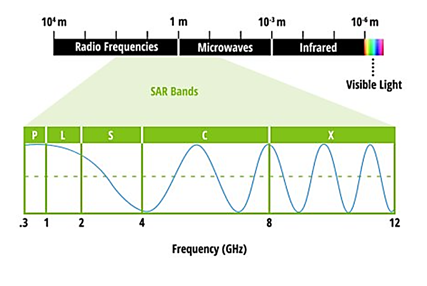
Soil Moisture Active Passive (SMAP) is a metric utilized to measure soil moisture. The SMAP project is a global orbiting observatory that quantifies the water content in surface soil. Soil moisture is an essential indicator in agriculture, drought and flood forecasting, weather forecasting, and other domains [6]. SMAP quantifies the water content in the upper 5 cm of soil over all terrestrial regions that are neither frozen nor submerged in water. Furthermore, it differentiates between frozen and thawed soil. SMAP analyzes the moisture content within the minerals, geological materials, and organic particles found in soil globally, specifically in regions where the ground remains unfrozen [8]. SMAP cannot detect ice, but it can assess liquid water in the uppermost layer of the Earth [9]. The soil's moisture content influences the emission of microwave radiation, although this energy exists in all soil types [10]. Microwave energy escalates with arid soil and diminishes with moist soil. This radiation is quantified using radiometers, enabling scientists to ascertain the water content [11]. SMAP measures radiation in the L-band microwave spectrum (30–15 cm & 1-2 GHz frequency), as this wavelength may penetrate clouds, enabling SMAP to assess soil moisture under cloudy situations [12].
3. Methodology
The researchers performed a three-year examination of moisture content along the ADF to pinpoint areas with rising moisture content values [13]. An increase in moisture content may indicate inadequate drainage [14]. Historical analysis facilitates the identification of places with elevated moisture levels, which may be corroborated with historical data pertaining to the status of the ADF [15].
Soil moisture is quantified using Soil Moisture Active Passive (SMAP) [4]. The SMAP mission is an orbital observatory that quantifies the water content in surface soil globally. Soil moisture is a crucial metric for meteorological forecasting, drought and flood predictions, agriculture, and other applications. SMAP quantifies the moisture content in the first 5 cm of soil over all terrestrial regions that are neither submerged nor frozen [7]. It also differentiates between frozen and thawed ground. In areas where the ground is unfrozen, SMAP quantifies the water content present among the minerals, rocky substances, and organic matter in soil globally [8] (Feng et al., 2024). SMAP quantifies liquid water in the uppermost layer of soil but is incapable of measuring ice [9]. All soil types emit microwave radiation; however, the quantity of released energy varies with the water content. As soil moisture decreases, microwave energy increases; conversely, as soil moisture increases, microwave energy decreases [11] (Abdulraheem et al., 2024). Radiometers quantify this radiation, enabling scientists to compute water content [12]. SMAP quantifies radiation in the L-band microwave spectrum, namely within the 30–15 cm wavelength range and 1–2 GHz frequency (refer to fig.1) [4]. This radiation wavelength penetrates clouds, enabling SMAP to assess soil moisture irrespective of cloud cover.
SMAP was inaugurated in January 2015 and commenced operations in April 2015, equipped with two instruments for soil moisture measurement: an active radar and a passive radiometer (refer to table 1) [16]. The radar sensor became inoperative in early 2015 due to a malfunction in the radar power source, however it gathered about three months of scientific data, which may be accessed at the Alaska Satellite Facility [17]. The passive L-band radiometer acquires daily data at 6 a.m. 6 p.m. (descending) Local solar time ascends for comprehensive world coverage every 2 to 3 days [18]. This allows for the observation of global changes over time spans that encompass significant storms and recurring seasonal measurements [19].
Table 1: The Radiometer of SMAP.
|
Frequency |
Polarization |
Resolution |
Relative accuracy |
|
1.41 Ghz |
H, V |
36-km original, 9-km enhanced |
1.3 K |
SMAP's radiometer captures naturally emitted radiation from the surface using a 20-foot-wide mesh antenna that rotates 14 times per minute, the largest spinning antenna in space.
4. Results/Findings
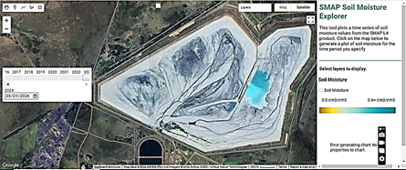
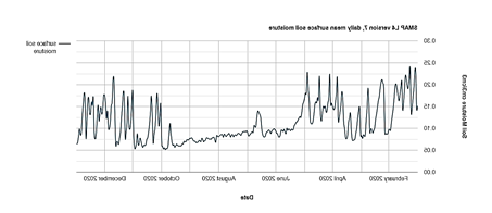
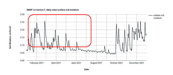
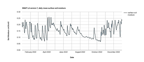
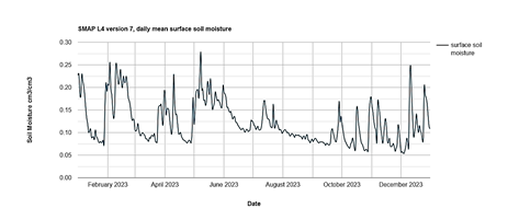
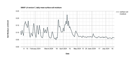
The soil moisture analysis was performed from 2020 to 2024. An assessment of the water content in the surface soil was conducted. SMAP quantified the water content in the uppermost layer (5 cm) of soil. It was determined to average 0.09 cm³/cm³ due to the ashing and the associated damming required by the ashing process. The researchers choose the dam facility as their focal point on the SMAP visualization application, as illustrated in Figure 2.
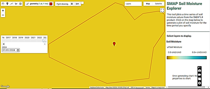
The researchers delineated a polygon representing the study region of the fly ash dam plant and selected a four-year timeframe, as illustrated in Fig. 3.
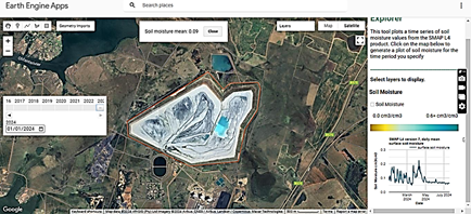
The researchers selected the soil moisture tab for viewing and analyzed the generated results by adjusting the zoom level of our study region. Upon selecting the stop drawing tab and clicking on the map to display the soil moisture value, the researchers obtained a measurement of (0.09 cm3/cm3) in this instance (see fig.4). Figure 3 (highlighted in red) indicates that any value beyond 0.6 cm³/cm³ is deemed worrisome.
Figures 5 to 9 clearly indicate that soil moisture peaks throughout the summer months at the ash dam site. Soil moisture is diminished throughout the cold months. Precipitation occurs consistently throughout the summer months. The winter months are likely drier. Fly ash facilities operate continuously throughout the year. The water dams remain operational year-round. This renders ashing throughout the summer months essential. Monitoring soil moisture throughout the hot months is therefore essential.
5. Conclusions and recommendations
Soil moisture is diminished throughout the cold months. Precipitation occurs consistently throughout the summer months. The winter months are likely drier. Ashing at the ADF occurs year-round. The water dams at the ADF are functioning year-round. This renders ashing throughout the summer months essential. Monitoring soil moisture during the hot months is consequently essential. Phreatic levels must be meticulously monitored during the warmer months. In summary, it is necessary to examine whether the triggering criteria have evolved over time to associate the trend in soil moisture with rainfall.
6. Acknowledgement/Funding
This study is part of a collaborative effort at ESKOM, the Centre of Applied Research and Innovation in the Built Environment (CARINBE). It was financed under task order 2, pertaining to the research and development of a proof of concept for ash dam monitoring (Geomatics), under the project titled: Civil & Structural Engineering and Ash Dams, contract number: 4600074129. The authors assert that there is no conflict of interest.
7. References
[1] T. Sebele, 2024. From Coal to Renewable Energy: Perspectives on South Africa's Energy Transition for a Sustainable Future (Doctoral dissertation, University of the Witwatersrand, Johannesburg).
[2] S. Shukla, S. Kadian, and R.J. Narayan, 2024. Electrochemical applications of fly ash as surface modifier: sustainable mitigation of industrial residue. Journal of Solid State Electrochemistry, pp.1–22. View Article
[3] A.D. Jayasinghe, 2024. A local perspective of the socio-environmental vulnerability to environmental pollution and economic crises: a case of locals around a coal power plant in Sri Lanka. Environment, Development and Sustainability, 26(2), pp.5431–5450. View Article
[4] A. Farahani and M. Ghayoomi, 2024. Soil moisture-based global liquefaction model (SMGLM) using soil moisture active passive (SMAP) satellite data. Soil Dynamics and Earthquake Engineering, 177, p.108350. View Article
[5] L.J. Wernicke, 2024. Planetary Water: Quantifying Water Stored in Martian Hydrated Minerals and Downscaling SMAP Soil Moisture to 3km Using CYGNSS Reflectivity (Doctoral dissertation, University of Colorado at Boulder).
[6] S.K. Gupta, S.K. Singh, S. Kanga, P. Kumar, G. Meraj, D. Sahariah, J. Debnath, K. Chand, B. Sajan, and S. Singh, 2024. Unearthing India’s soil moisture anomalies: impact on agriculture and water resource strategies. Theoretical and Applied Climatology, 155(8), pp.7575–7590. View Article
[7] S. Veysi and E. Galehban, 2024. Conceptual of soil moisture based on remote sensing and reanalysis dataset. In Remote Sensing of Soil and Land Surface Processes (pp. 77–98). Elsevier. View Chapter
[8] S. Feng, J. Chen, S.B. Jones, G. Flerchinger, M. Dyck, V. Filipovic, Y. Hu, B. Si, J. Lv, Q. Wu, and H. He, 2024. Miscellaneous methods for determination of unfrozen water content in frozen soils. Journal of Hydrology, p.130802. View Article
[9] H. Xu, 2024. Electromagnetic Modelling for the Active and Passive Remote Sensing of Polar Ice Sheet and Signal of Opportunity (SoOp) Land Observation (Doctoral dissertation). View Thesis
[10] Priyanka, I.E. Wood, A. Al-Gailani, B.W. Kolosz, K.W. Cheah, D. Vashisht, S.K. Mehta, and M.J. Taylor, 2024. Cleaning Up Metal Contamination after Decades of Energy Production and Manufacturing: Reviewing the Value in Use of Biochars for a Sustainable Future. Sustainability, 16(20), p.8838. View Article
[11] M.I. Abdulraheem, H. Chen, L. Li, A.Y. Moshood, W. Zhang, Y. Xiong, Y. Zhang, L.B. Taiwo, A.A. Farooque, and J. Hu, 2024. Recent Advances in Dielectric Properties-Based Soil Water Content Measurements. Remote Sensing, 16(8), p.1328. View Article
[12] X. Zhang, X. Zhang, B.K. Terfa, W.H. Nam, J. Zeng, H. Ma, X. Gu, W. Du, C. Wang, J. Yang, and P. Wang, 2024. Mapping global drought-induced forest mortality based on multiple satellite vegetation optical depth data. Remote Sensing of Environment, 315, p.114406. View Article
[13] M. Rashid, M.I. Afzal, and M. Arslan, 2024. Time Series Analysis Metrological Parameter Maximum Temperature Forecast in the Region of Karachi Using Seasonal Arima Model. SSRN 4980707. View Preprint
[14] J.A. de Wit, M.H. van Huijgevoort, J.C. van Dam, G.A. van den Eertwegh, D. van Deijl, C.J. Ritsema, and R.P. Bartholomeus, 2024. Hydrological consequences of controlled drainage with subirrigation. Journal of Hydrology, 628, p.130432. View Article
[15] L.E. Rubillos, A.F. Mangubat, M.A. Seno, J.C. Caragay, N. Salazar, J.A. Caladcad, and R. Villeta, 2024. Time series analysis of wheat moisture content variations for grain storage systems. Journal of Stored Products Research, 108, p.102395. View Article
[16] K.Y. Kim, Z. Zhu, R. Zhang, B. Fang, M.H. Cosh, A.L. Russ, E. Dai, J. Elston, M. Stachura, A.J. Gasiewski, and V. Lakshmi, 2024. Precision Soil Moisture Monitoring with Passive Microwave L-band UAS Mapping. IEEE Journal of Selected Topics in Applied Earth Observations and Remote Sensing. View Article
[17] A. Gajurel, A.J. Puppala, N. Biswas, and H.R. Chimauriya, 2024. Use of Orbital Synthetic Aperture Radar Data in Monitoring Geotechnical and Transportation Infrastructure Assets. In Geo-Congress 2024 (pp. 513–522). View Paper
[18] S.L. Ustin and E.M. Middleton, 2024. Current and Near-Term Earth-Observing Environmental Satellites, Their Missions, Characteristics, Instruments, and Applications. Sensors, 24(11), p.3488. View Article
[19] R. Roca, T. Fiolleau, V.O. John, and J. Schulz, 2024. METEOSAT Long-Term Observations Reveal Changes in Convective organization over Tropical Africa and Atlantic Ocean. Surveys in Geophysics, pp.1–20. View Article
[20] H. Guo, X. Wang, F. Chen, and C. Wang, 2024. Remote Sensing Technology and Archaeology. In Introduction to Space Archaeology (pp. 85–151). Singapore: Springer Nature Singapore. View Chapter